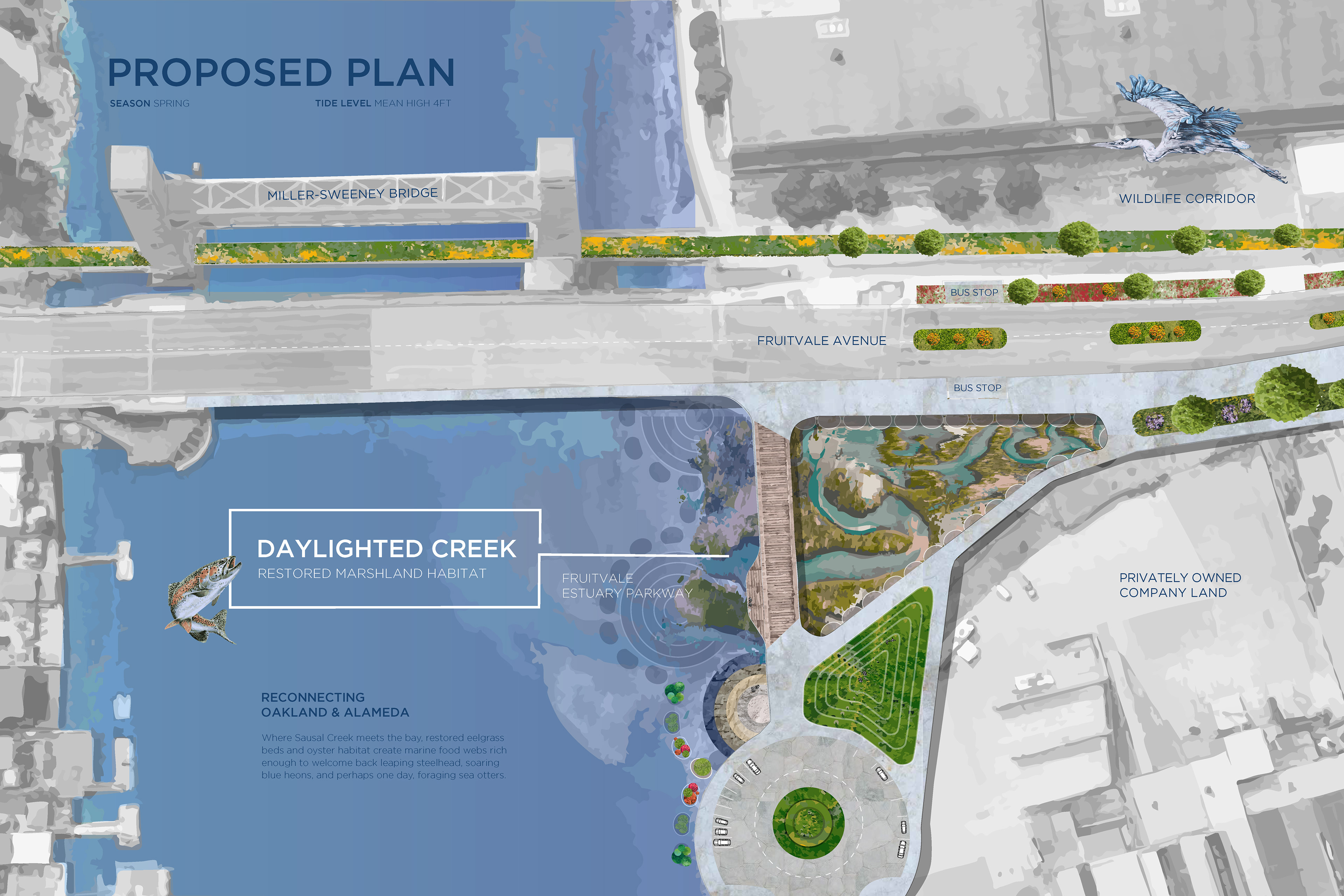

PROPOSED PLAN & ELEVATION VIEWS (Above): Visions of abundance restored, where children and families gather to tend or recreate along the shoreline, while scuba divers swim amongst schools of fish, eelgrass meadows, and Olympia oyster beds. These designs envision a revitalized and regenerative habitat able to support wildlife and human recreation. Digital illustrations (print size 36"x24" and 36"x17") by Heather Hayashi.
HEALING URBAN WATERS: Sausal Creek Tidal Confluence
Year: 2025
Project Details: Collaborative Design Project
Institution Program: University of California, Berkeley, College of Environmental Design (Summer Institute, InLand)
Site: Fruitvale, Oakland, CA
Team: Hayashi, H., Delaney-Lewis, E., Pan, S., Towle, G., Vitakis, E.
My Roles: Graphic Designer (GIS Data Visualization, Regional History Timeline)
Key Contributions: Regional History Research, Visual Communication (GIS Data Visualization, Regional History Timeline)
CONTEXT & RESEARCH
The Long Arc of Healing, Context & Ethics: Where Sausal Creek meets San Francisco Bay, an estimated 26,000 residents lack safe access to blue-green space. This deeply wounded landscape is defined by centuries of genocide, land theft, and systemic erasure. These structural harms—from the attempted erasure of Ohlone lifeways and Traditional Ecological Knowledge, which guided the care for these once-abundant landscapes for millennia, to the industrial pollution and redlining of today- defined our starting point.
Deep-Time Spatial Analysis: To truly heal this site, I initiated research to understand the deepest roots of its injury. Professor Diego Romero challenged us to think across space and time, inspiring me to trace the longest arc of ecological transformations—from its origins as a seafloor over which Plesiosaurs swam, to a continent bridged by glacial sheets of ice, and the evolution of the first Redwood forests. Hope for multispecies recovery developed as maps and research revealed sacred Ohlone shell mounds alongside geological evidence. This validated ancestral knowledge and traditional oral stories of a land tended for abundance: a rich interwoven tapestry of human and non-human relatives thriving from the fishery's generous nourishment.
Food Sovereignty & Estuary Return: This deep-time research became the temporal framework that allowed our diverse approaches to coalesce into a collaborative vision of potential recovery. The framing led the team to reject modest creek daylighting in favor of a systems-level intervention: an expansive estuary return. Here, we envisioned lush shorelines tiered with halophyte plant communities that offer phytoremediation, buffer sea level rise, stabilize soils against erosion, and provide nutritious Native plant foods—like Tule, Pickleweed, and Sea lavender—for sustenance. Lush submarine garden beds of Sea lettuce and rolling Seagrass meadows would provide fish and Sea otter nurseries.
Design Philosophy (Key Principles): A philosophy crystallized during our site visits: when you design for the most vulnerable—whether unhoused communities who deserve care, the smallest endangered mouse, a drowning bee, or disrupted steelhead trout—you create systems safe for all life forms to thrive. When natural systems are restored for the most sensitive, abundance becomes possible for all.
COLLECTIVE VISION & STRATEGIC INTERVENTION
Heather's work translated shared goals of environmental healing and community resilience into tangible spatial interventions, transforming the infrastructure of extraction into landscapes of care and learning. Our collaborative design emerged from a simple truth: honoring the abundance that surrounds us dispels misconceptions of food insecurity and scarcity.
The Commons & Mariculture Expansion: Recognizing the commons as a living shoreline where abundance is possible through reciprocal relationships with the land—and one another. All are welcome, all belong, and no one should be allowed to go hungry. Responding to the watershed history of dominance and dispossession, I expanded the project scope into the intertidal zone, proposing submarine tidal gardens and applying principles of regenerative mariculture and coastal foodway revitalization.
Blue-Green Tidal Gardens: To transform the site's massive concrete culverts, Heather designed the adaptive reuse intervention: the functional, interpretive 4-Level Tidal Garden Beds. This marine system supports polyculture mariculture by re-establishing Olympia oyster-clam-eelgrass beds and fostering conditions for respectful halophyte gathering. Physically converting infrastructure of erasure into "Living Classrooms" that teach tidal rhythms, reconnecting humans with the natural cycles of their environment.
Multispecies Corridor Bridge: Inspired by observing a drowning bee, I conceptualized creatively reusing the decommissioned railway bridge as a vital Multispecies Corridor, metaphorically reconnecting Alameda and Oakland after their 1902 separation in alignment with the Room to Roam Act (A.B. 1889).
Visualization as Pedagogy: Beyond project site photo documentation, hand-drawn studies, and final large-scale digital illustrations of the plan and elevations, Heather designed and created the Trout Culvert Access Tidal Levels Animation. This visualization translated complex technical calculations of sea levels (provided by Grace Towle) into clear, accessible spatial and temporal graphics, which was essential for communicating the project’s educational mission and dynamic function to the public.
In summary, this project proposes that true community and ecological repair is inseparable from cultural revitalization, turning infrastructural violence into landscapes of reciprocal abundance and multispecies care.


HISTORICAL COLLAGE & GRAPHIC TIMELINE (Above): These graphics focus on telling the story of the people of the Oakland/Fruitvale area. These images create a snapshot; the greater story exists in the reshaping of Sausal Creek. If you listen to the story of the river, you will see the story of the voices who have been removed from the history of the region. Graphic illustrations by Elieza Delaney-Lewis.
FRUITVALE & SAUSAL CREEK: A BRIEF HISTORY
Long before Oakland was a city, Sausal Creek flowed from the East Bay hills through oak woodlands, grasslands, wetlands, and marshes to San Francisco Bay. The creek and its surrounding landscape sustained Ohlone communities, who fished, gathered plants and acorns, and relied on the creek for water and other resources. Spanish and later American settlement transformed the watershed. Cattle grazing, logging, and agriculture altered the hills and creek corridors, while the Gold Rush brought rapid demand for lumber. By the 1850s, much of the area's original redwood forest had been cleared.
The fertile lands along lower Sausal Creek soon became known for orchards. In 1856, horticulturalist Henderson Lewelling established an orchard he called Fruit Vale, helping give today's Fruitvale district its name. Fruit production became an important part of the region's economy. As Oakland grew, Sausal Creek and its wetlands were increasingly engineered for development. Roads, railroads, gravel extraction, canals, and buildings reshaped the creek and its delta. Unlike several other East Bay creeks, Sausal Creek historically reached a broad area of sediment deposited against older sand deposits near the Bay. Geological mapping identifies both young alluvial sediments and artificial fill across the lower watershed. Older dune sands lie beneath portions of Oakland and Alameda, which explains why the lower creek and its surrounding wetlands could be so readily reshaped.
In the nineteenth century, the area now occupied by the Oakland Estuary and surrounding waterways was a mixture of tidal channels, marshes, and low-lying land. Alameda was originally a wooded peninsula known as the Encinal rather than the island city familiar today. As Oakland's harbor developed, engineers dredged and constructed channels through the lowlands. Around 1900, a tidal canal was created near the mouth of Sausal Creek, completing the separation of Alameda from the mainland. The downstream portion of Sausal Creek was subsequently relocated in an effort to reduce sediment accumulation in the new channel. It was later returned toward its former course, and the lower creek was progressively straightened and confined to make more land available for development. The modern mouth of Sausal Creek is therefore only a remnant of a much larger historical delta. Much of the former marsh and creek landscape has been filled, channelized, or placed underground.
These changes were part of a much larger transformation of San Francisco Bay. Since the Gold Rush, extensive areas of the shallow Bay and its shoreline have been filled for ports, industry, transportation, housing, and other development. The Bay covered approximately 787 square miles in 1849; today it is roughly 550 square miles. Today, Sausal Creek remains a living thread through Fruitvale and East Oakland, even though much of its historic watershed lies beneath streets, buildings, and fill. Its story reflects the broader history of the region: an Indigenous landscape transformed by settlement, agriculture, industry, and urbanization—and an ongoing effort to understand and restore the waterways that remain.


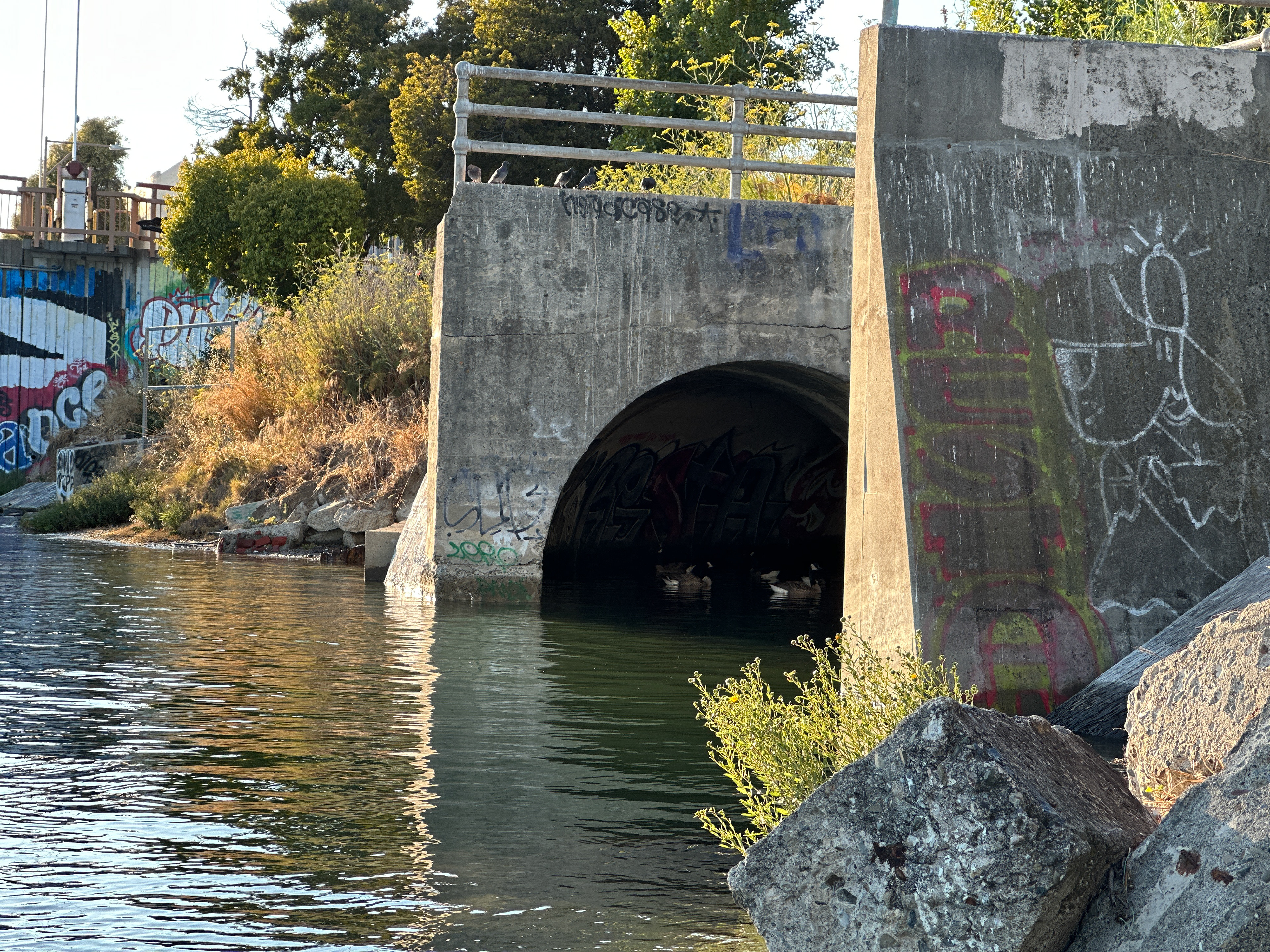
EXISTING SITE PHOTOS (Above): Site visits at different tidal levels revealed both degradation and hope within the same frame. Heather documented visible pollution, but discovered signs of recovery: baby fish, young sea lavender establishing, and thickets of pickleweed. (Left) View at noon, low tide, from inside the culvert looking toward daylight; (Middle) view on the Miller-Sweeney Bridge of the culvert; (Right) Canadian geese and pigeons congregate around and within the culvert at high tide near dusk. Courtesy of Heather Hayashi.


EXISTING PLAN & ELEVATION VIEWS (Images Above): A degraded urban landscape heavily paved with concrete leaves little desirable space for pedestrians and wildlife; the view reveals an environment designed for vehicles and extractive industrial commerce over multispecies community and human-nature connection. (Below) While pickleweed has been identified along the shoreline (endangered salt marsh harvest mouse habitat) and a peregrine falcon pair nests in the decommissioned railway towers, it is suspected that the steelhead trout cannot return through the culvert during low tide to complete their life cycle. Native sea lettuce and invasive bladderwrack indicate compromised but recovering tidal ecology. Oyster drills threaten Olympia oyster restoration efforts. Digital illustrations (print size 36"x24" and 36"x17") by Heather Hayashi.


EXISTING & PROPOSED 3-SECTION ELEVATIONS (Images Above): Top series depicting environmental burdens such as oil seeping from car traffic, trash accumulating in water and along the shoreline, and unhoused communities seeking shelter in spaces the city has abandoned. The culvert shows minimal fish passage and no shellfish or vegetation. These sections document how decades of industrial extraction have created conditions of scarcity for all beings who call this place home. In contrast, bottom series (Below) envision scenes of intergenerational families, fishing cormorants, sea otter colonies comfortable enough to bask ashore, elk, mother bears with cubs, and rich underwater biodiversity. These sections imagine what becomes possible when we design from a reciprocal relationship with the land: a future where boats, housing, wildlife, and shellfish beds thrive together in restored estuarine habitat. Digital illustrations by Heather Hayashi.


HAND-SKETCHES AND DIGITAL TIDAL LEVELS ANIMATION STUDY (Image Below Left): To better understand tidal barriers, the animation shows how low tide prevents fish from accessing the culvert, while king tide, high tide, and sea level variations affect habitat availability. (Image Below Right) Hand-drawn studies of culvert anatomy, tidal cycles, eelgrass, and pickleweed informed the design of repositioned culvert pieces as tidal ecotone markers. Animation and illustrations by Heather Hayashi.
APPENDIX